Water Quality Assessment for Ecosystem Health in Conservation Areas
Continuous water quality monitoring reveals pollution impacts on protected ecosystems, enabling evidence-based conservation decisions.

What You'll Achieve
Detect Pollution Events Before Ecosystem Damage
Continuous monitoring reveals hypoxic conditions and contaminant plumes within hours, enabling rapid response before widespread mortality occurs.
Document Baseline Conditions for Protection Effectiveness
Multi-year records establish baselines that distinguish natural variation from pollution impacts, creating evidence for regulatory enforcement.
Demonstrate Conservation Success to Stakeholders
Quantified improvements in dissolved oxygen, turbidity, and temperature provide proof points that justify continued protection and secure funding.
Proving Protection Works Requires Continuous Environmental Evidence
Conservation areas succeed when they measurably improve ecosystem health — but proving that improvement demands water quality data that traditional monitoring approaches struggle to provide. Sporadic grab sampling misses pollution pulses that stress or kill organisms between sampling events. Hypoxic conditions may develop and resolve within days, leaving no trace for monthly surveys to detect.
The gap between sampling visits leaves managers uncertain whether habitat quality is improving, degrading, or simply fluctuating naturally. Without continuous records, distinguishing a genuine pollution event from seasonal variation becomes guesswork. When funding reviews or permit renewals demand proof of conservation effectiveness, managers lack the quantified baselines and documented trends that demonstrate success. Traditional approaches — requiring vessel time, laboratory analysis, and specialized personnel — impose high costs that limit spatial coverage and temporal frequency, leaving critical questions about ecosystem health unanswered.
Autonomous Water Quality Networks Reveal Ecosystem Response to Protection
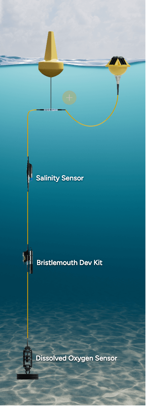
What Gets Deployed
A distributed network of moored systems captures dissolved oxygen, temperature, turbidity, salinity, and pH across the conservation area. Interior stations track conditions where recovery should occur, while perimeter stations monitor incoming water quality. Because sensors operate continuously without vessel support, the network maintains observation through all seasons and weather conditions.
What the Data Reveals
Over weeks and months, continuous observations reveal patterns invisible to periodic surveys. When dissolved oxygen drops into hypoxic levels, automated alerts enable rapid assessment of extent and duration — distinguishing brief natural fluctuations from sustained pollution events. Turbidity spikes track sediment plumes or algal blooms, revealing whether stressors originate within the protected area or arrive from outside sources.
Across seasons, the continuous record shows whether hypoxic events are becoming more frequent, whether temperature extremes are pushing beyond tolerance limits, and whether baseline conditions are improving as protection takes effect. When pH trends reveal acidification stress or salinity excursions indicate pollution, the data pinpoints when conditions shifted and how long impacts persisted.
What This Enables
Conservation managers can respond to pollution events within hours rather than discovering impacts weeks later. The continuous baseline enables confident separation of natural variation from anthropogenic degradation, strengthening regulatory enforcement when violations occur. Over multi-year timescales, quantified improvements in water quality metrics provide evidence that justifies continued protection to funding agencies, demonstrates success to stakeholders, and supports expansion when data reveals positive effects in adjacent areas.
Recommended Systems (2)
The monitoring approach divides into complementary roles: interior stations track protected habitat conditions where ecosystem recovery should occur, while perimeter stations capture incoming water quality from adjacent areas. For larger conservation areas, multiple interior stations provide spatial coverage across habitat zones.
System Overview
Purpose
Tracks dissolved oxygen, temperature, and turbidity within protected habitat to document baseline conditions and detect stress events.
Deployment Context
Moored within the conservation area at locations representative of critical habitat types. Multiple instances positioned across the monitoring area as needed for spatial coverage.
Sensors
Required
Dissolved Oxygen
Reveals hypoxic events below 2 mg/L threshold that trigger mortality, tracks whether protection improves baseline oxygen levels over time.
Temperature
Documents thermal stress approaching species tolerance limits, distinguishes seasonal patterns from climate-driven shifts.
Turbidity
Detects sediment plumes and algal blooms that reduce light penetration and stress benthic communities.
Important
Salinity
Identifies freshwater pollution events and tracks estuarine mixing patterns that influence habitat suitability for target species.
Use of this content is subject to Sofar's Terms of Use and Privacy Policy.